243 Acres of Agricultural Land for Sale in Bullhead City, Arizona
243 Acres, Bullhead City, AZ
Images
Map
Street
$1,215,000
243 acres
Active sale agoEst $11,480/mo
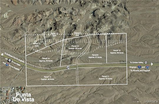
243 Acres APN's: (349-02-007A, 008A, 010A, 014A - north side of 68) and (011A & 015A - south side of 68). 2020 Taxes total for all 6 properties: $1,010.76. . The 2 westernmost parcels, #14 on the north and # 15 on the south share a common boundary with the Bullhead City city limits. Property is in the Mohave Water Conservation District, an independent governmental unit which is a part of Mohave Valley Water Authority. Approximately 1 mile of Hwy 68 frontage. Seller would consider selling off parcels on south side together or north side together. (Some parcels if sold independently, would have higher values than others). Zoning AR/10A
Directions
Hwy 68 just above Punto De Vista; 4 Parcels on North side of 68, 2 parcels on South side of 68
Property details
- County
- Mohave County
- Elevation
- 1,519 feet
- MLS Number
- WARDEX 981679
- Date Listed
Parcels
- 349-02-007A
Property taxes
- 2023
- $1,011
Resources
Listing history
| Date | Event | Price | Change | Source |
|---|---|---|---|---|
| July 28, 2021 | New listing | $1,215,000 | — | WARDEX |
Payment calculator

Contact listing agent
By submitting, you agree to the terms of use, privacy policy, and to receive communications.