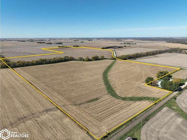
Land for Sale in Mount Auburn, Iowa
52nd St, Mount Auburn, IA 52313
148.03 acres, m/l, located approximately 6 miles southeast of of La Porte City, Iowa on the south side of 52nd St. This level to gently rolling farm has 136.58 FSA/Eff. crop acres with a CSR2 of 82.40. There are 5.47 acres enrolled in CRP contracts that pay $300/acre or a total of $1,641 annually. These 5.47 acres are split between three contracts with 1.85 acres in CP-8A contract that expires Sept. 30, 2032, 2.28 acres in CP-21 contract that expires Sept. 30, 2035 and 1.34 acres in CP-21 contract that expires Sept. 30, 2036. This is a productive Benton County farm with an 82.40 CSR2. The seller would consider dividing this farm. Seller has an additional tract of land for sale located southwest of this property. See additional listing.
Location
- Street address
- 52nd St
- County
- Benton County
- Zip code
- 52313
- Elevation
- 830 feet
Directions
From La Porte City: 3 1/2 miles south on US-218, 4 miles east on 53rd St., 1 mile north on 19th Ave. and 1/2 mile east on 52nd St. The property is on the south side of the road.
Property details
- Acreage
- 148.03 acres
- Zoning
- Agriculture
- MLS #
- NCMLS 6344613
- Posted
Property taxes
- 2025
- $5,280
Parcels
- 38006250
Legal description
That part of the E 1/2 NW 1/4 and the NE 1/4 of Section 15, Township 86 North, Range 11 West of the 5th P.M., Benton County, Iowa, excluding the building sites. Final abstract/title documents to govern
Listing history
| Date | Event | Price | Change | Source |
|---|---|---|---|---|
| Nov 16, 2026 | New listing | $2,220,450 | — | NCMLS |