Land for Sale in Milton, Florida
8260 Gin Rd, Milton, FL 32571
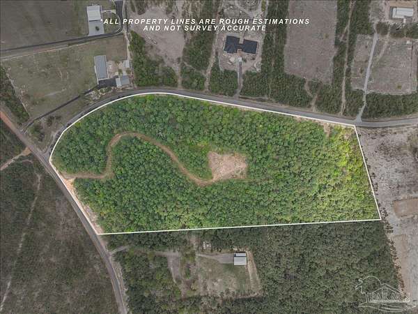
15.043 acres of peaceful undeveloped land situated on a paved, county maintained road with no HOA. Recorded deed restrictions help preserve the rural residential character of the surrounding community. The property offers a naturally high and relatively level homesite that may help simplify future building plans, subject to buyer verification. Enjoy privacy, space and country retreat living, conveniently located just minutes from Pace and Milton amenities.
Location
- Street address
- 8260 Gin Rd
- County
- Santa Rosa County
- Zip code
- 32571
- Elevation
- 209 feet
Directions
From 5Points in Pace FL, (where Quintette road meets Chumuckla highway, and Woodbine road), head north on Chumuckla Highway (FL-197) towards Chumuckla. Passby Lead Academy and the West Florida soccer fields on your left. Passby Williard Norris junction on your right, keep heading straight up Chumuckla Highway, until you reach 10 mile road to which you will turn left into (There is a left hand turning lane). Turn right on Marion Way, and left on Molino Bridge Road. Turn right on Gin Road. Keep on Gin Road until you reach WaterFall Street, the entrance is just before it. The lot is corner of Gin Road and Waterfall Street - access to enter the lot is on Gin Road.
Property details
- Acreage
- 15.043 acres
- MLS #
- PAR 687889
- Posted
Parcels
- 283N300000001080000
Legal description
*DESCRIPTION UPDATE FOR 2021* COMMENCE AT SOUTHWEST CORNER OF SECTION 28 TOWNSHIP 3 NORTH RANGE 30 WEST; THENCE SOUTH 88 DEGREES 09 MINUTES 02 SECONDS EAST ALONG SOUTH SEC LINE 2755.32 FEET; THENCE NORTH 28 DEGREES 19 MINUTES 09 SECONDS WEST 2454.36 FEET TO THE POINT OF BEGINNING; THENCE SOUTH 68 DEGREES 28 MINUTES 46 SECONDS WEST A DISTANCE OF 1289.46 FEET TO CURVEE EAST R/W OF GIN ROAD; THENCE ALONG ARC OF A CURVE 375.06 FEET TO EAST R/W OF AN UNNAMED ROAD (CURVE RADIUS = 1734.25', CENTRAL ANGLE = 12 DEGREES 23 MINUTES 29 SECONDS, AND CHORD BEARING = NORTH 49 DEGREES 32 MINUTES 10 SECONDS WEST); THENCE RUN NORTH 9 DEGREES 34 MINUTES 25 SECONDS EAST ALONG EAST R/W 132.20 FEET TO A POINT OF INTERSECTION; THENCE CONTINUE ALONG R/W NORTH 32 DEGREES 11 MINUTES 47 SECONDS EAST 23.44 FEET TO A CURVE; THENCE ALONG ARC OF CURVE & ALONG SOUTH R/W OF RD 584.95 FEET TO POINT OF TANGENCY, SAID CURVE (RADIUS = 630.00' CENTRAL ANGLE = 53 DEGREES 11 MINUTES 54 SECONDS & CHORD BEARING = NORTH 58 DEGREES 47 MINUTES 44 SECONDS EAST) THENCE CONTINUE ALONG THE SOUTH R/W NORTH 85 DEGREES 23 MINUTES 41 SECONDS EAST 820.06 FEET; THENCE SOUTH 28 DEGREES 19 MINUTES 09 SECONDS EAST 316.07 FT TO THE POINT OF BEGINNING, BEING KNOWN AS PARCEL 5-E OF AN UNRECORDED SUB AS DES IN OR 4050 PG 1830 (OUT OF #1.6 FOR 2017) LESS ALL MINERAL RIGHTS
Nearby schools
| Name | Type |
|---|---|
| Chumuckla | Elementary |
| Central | Middle |
| Central | High |
Listing history
| Date | Event | Price | Change | Source |
|---|---|---|---|---|
| Aug 22, 2026 | New listing | $415,000 | — | PAR |