70.7 Acres of Recreational Land for Sale in Clayhole, Kentucky
854 Upper Laurel Fork Rd, Clayhole, KY 41317
Images
Map
$80,000
70.7 acres
Active sale$10k dropEst $808/mo
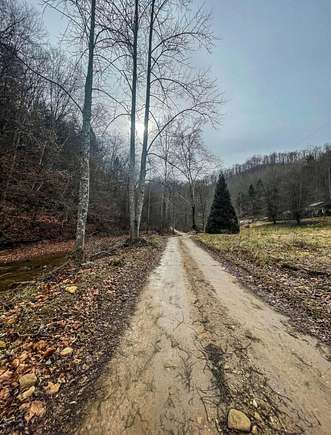
Over 70 acres of high use land. Can be used for hunting or it's natural resources. Dreaming of building your beautiful home or cabin, this would be the perfect place. Very peaceful and quiet. The desires of your heart can come true all in one place. The options are endless. Make your appointment to tour it today.
Directions
Take I-64 E Mountain Pkwy exit 43. Follow KY-15 South and KY-476 South to Upper Laurel Fork Rd. Property is on the right.
Property details
- County
- Breathitt County
- School District
- Breathitt County - 64
- Zoning
- AR
- Elevation
- 801 feet
- MLS Number
- LBAR 23022066
- Date Listed
Nearby schools
| Name | Level | District | Description |
|---|---|---|---|
| LBJ | Elementary | Breathitt County - 64 | — |
| Sebastian Middle | Middle | Breathitt County - 64 | — |
| Breathitt High | High | Breathitt County - 64 | — |
Listing history
| Date | Event | Price | Change | Source |
|---|---|---|---|---|
| Mar 6, 2024 | Price decrease | $80,000 | $10,000 -11.1% | LBAR |
| Jan 16, 2024 | Price decrease | $90,000 | $10,000 -10% | LBAR |
| Nov 16, 2023 | New listing | $100,000 | — | LBAR |
Payment calculator
Crystal Taylor
Lifstyl Real Estate
Contact listing agent
By submitting, you agree to the terms of use, privacy policy, and to receive communications.