180 Acres of Recreational Land for Sale in Baker City, Oregon
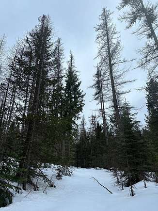
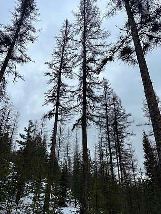


At the base of Twin Mountain this property is the gateway to the Elkhorn Mountains known to the old timers as the access road over the mountains to Sumpter. Known as the "Old Stagecoach Road". The property boasts 180 acres of well managed timber. It is estimated to have been logged about 25 years ago. Well managed, this property contains a significant amount healthy Western Larch, Douglas Fir, Spruce and other species. Hunting, fishing, camping, summer or winter recreation, this property can provide it. Sellers have applied for a "lot of record" to provide the ability to construct a dwelling.
Location:
Foothill Road West of Haines, and not far from the Anthony Lakes highway. T07SR38E TL 5500
Access:
From Baker City turn right onto US-30 W/10th St 12.5 mi Turn left onto Haines Cemetery Ln/Muddy Creek Rd 1.3 mi Turn right onto Muddy Creek Rd 0.3 mi Slight left onto Muddy Creek Ln 2.6 mi Continue onto Foothill Rd 1.0 mi Turn left onto Bulger Flat Ln 1.6 mi
La Grande 39 mi Ontario 89 mi Boise, ID 144 mi TriCities, WA 156 mi
Acreage:
The Timber property consists of 180 acres.
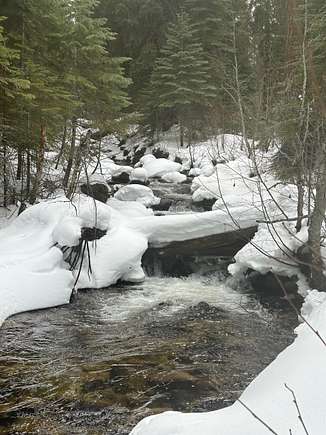
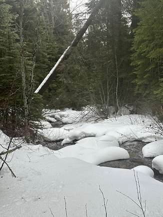
Mostly timbered. The North Powder River runs North to South though the entire length of the property. Riparian area is a mix of conifers and rushing water. Mansfield Ditch diverts out of the river and transects across the property providing a great opportunity for late season water access for all kinds of wildlife species.
Water:
Water is supplied by two different ditches.
Water Rights:
A timber property with no known water rights.
Grazing/Fencing: The property is NOT perimeter fenced.
Climate/Elevation/Rainfall:
4600' Elevation Average Temperature Baker (Recorded in the period 1951-1981)
(All units are Degrees Fahrenheit Month Avg Daily Max Avg Daily Min Avg Growing Deg Days January 35.7 19 27.4 38
February 42.6 23.6 27.4 51
March 49.7 26.5 38.1 71
April 59.5 31.5 45.5 194
May 68.3 38.6 53.5 419
June 76.4 45.1 60.8 624
July 85.9 50.3 68.1 871
August 84.3 48.4 66.6 825
September 76.5 41.7 59.1 573
October 62.9 33.8 48.8 270
November 46.8 27 36.9 53
December 37.6 21 29.3 17
Precipitation Month Average Inches Water Average Snowfall Inches January 1.17 7.4
February .76 3.8
March 1.04 2.5
April .92 .8
May 1.54 .2
June 1.33 0
July .69 0
August .68 0
September .69 0
October .69 .3
November 1.18 3.7
December 1.37 7
Total 12.06 25.7
Growing Season days Baker (data was recorded from 1951 - 1981)
Probability Higher than 24 deg F Higher than 28 deg F Higher than 32 deg F
9 yrs in 10 150 days 117 days 90 days
5 yrs in 10 180 days 150 days 115 days
2 yrs in 10 200 days 172 days 132 days
Last Freeze Dates in Spring Baker (data was recorded from 1951 - 1981)
Probability 24 deg F or lower 28 deg F or lower 32 deg F or lower
1 yr in 10 May 10 May 28 June 19
2 yr in 10 May 2 May 21 June 12
5 yr in 10 Apr 20 May 8 May 29
First Freeze Dates in Fall Baker (data was recorded 1951 - 1981)
Probability 24 deg F or lower 28 def F or lower 32 deg F or lower
1 yr in 10 Sept 29 Sept 18 Sept 8
2 yr in 10 Oct 6 Sept 24 Sept 13
5 yr in 10 Oct 18 Oct 5 Sept 22
Taxes:
2023 Property Tax - $458.65
Zoning:
550 Farm Use /EFU Vacant
Mineral Rights:
Any and all mineral rights (if any) owned by the seller will transfer with the sale of the property.
History of County/City:
Until 1861, the land now known as Baker County was an unsettled wilderness, Visited only by Indians and travelers on the Oregon Trail headed for the green valleys of Western Oregon. Then four men searching for the fabled Blue Bucket Mine in the fall of that year spent the night in Griffin Gulch, a minor gulley in the sagebrush-covered hills south of present-day Baker. These early adventurers found gold in the gulch and the rush was on.
The town of Auburn was soon established as the first settlement and base for exploration. By about 1870 the richest placers were exhausted, but quartz lodes were discovered and developed, although slowly, and by 1900 were substantially productive in the Cracker Creek, Cornucopia, and Sumpter districts. As placer production decreased, Auburn declined, and Baker became the most important town in the county.
BAKER DISTRICT MINING HISTORY Production in the Baker district has been chiefly from the placers in Griffin Gulch but this was in the early years and was unrecorded. After 1900 more than half of the gold produced in the district came from lode mines. Production of gold from 1906 through 1959 was 19,825 ounces from lode mines, 10,890 ounces from placers, and 5,437 ounces undifferentiated, a total of 36,152 ounces.
Education:
Baker School District has k-12 education. Additional educational opportunities include satellite colleges, technical institutes as well as an online charter school. Baker has two satellite colleges where adults can take classes. Baker Technical Institute offers community courses and job training/certification for both students and adults. The Baker Charter School's is an online accredited public school for grades k-12 with regional centers across the state. The school also has an early college program where students can earn their associates degree upon graduation from college.
Property details
- County
- Baker County
- Elevation
- 4,767 feet
- Date Listed
Resources
Listing history
| Date | Event | Price | Change | Source |
|---|---|---|---|---|
| Feb 27, 2024 | Under contract | $325,000 | — | — |
| Feb 21, 2024 | New listing | $325,000 | — | — |