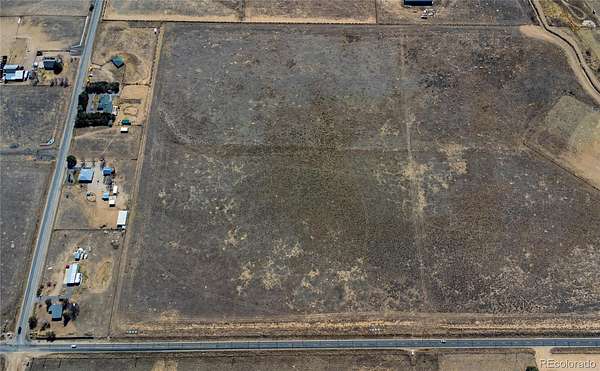
Agricultural Land for Sale in Brighton, Colorado
County Road 4, Brighton, CO 80603
Well permit in supplements! Well allows for 4 large animals, poultry, an ADU, and 39,000 square feet of yard/garden irrigation. If you’ve been waiting for the right piece of land to build your Colorado dream—this is it.
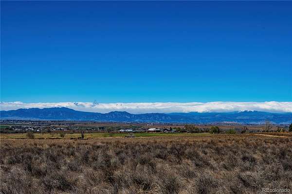
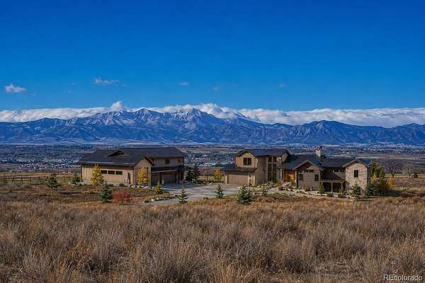
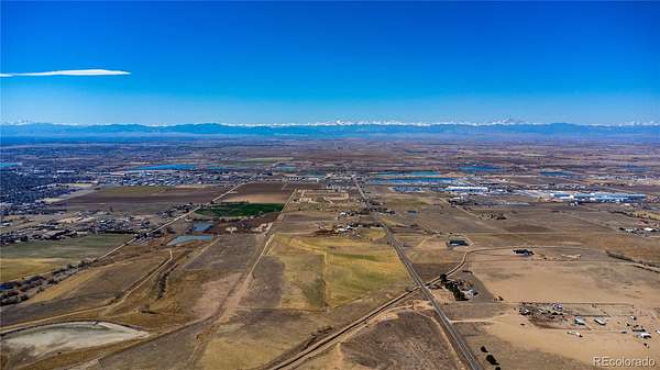
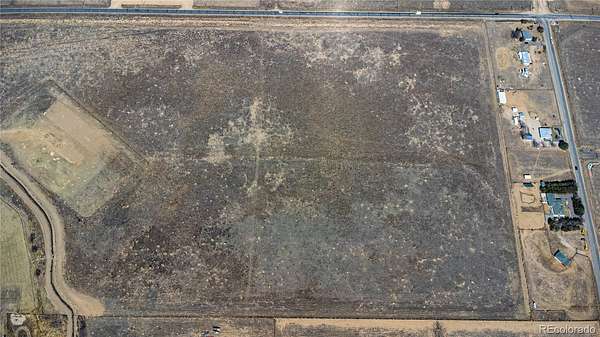
This 10-acre Brighton property delivers wide-open space, breathtaking Front Range views, and the kind of freedom that’s getting rare—no HOA, no restrictions holding you back. Bring your vision, your animals, your shop… whatever your lifestyle needs.
The flat, build-ready terrain makes planning simple, and with easy access to Road 4, you’re never too far from town while still enjoying that peaceful, country feel.
Morning coffee with mountain views, sunsets that stop you in your tracks—this is what Colorado living is supposed to look like.
Approximate GPS location for center of lot:
Lot A - 40.012204, -104.775750
Google Map Location: https://maps.app.goo.gl/D8JTsed3j6RM2JVg7
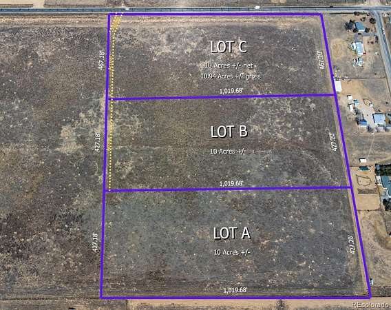
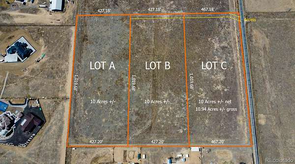
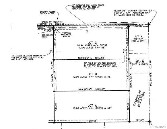
There are three lots for sale. Lot A – is MLS # 3633676. Lot B – is MLS # 5294567. Lot C – is MLS # 8402861.
- Listed by Roberta Sue Stewardson, (303) 523-4380, You 1st Realty
Location
- Street address
- County Road 4
- County
- Weld County
- Zip code
- 80603
- School district
- School District 27-J
- Elevation
- 5,084 feet
Property details
- Acreage
- 10 acres
- Zoning
- Ag
- Access
- Easement
- MLS #
- REcolorado 8402861
- Posted
Legal description
LOT A, LOT LINE ADJUSTMENT LLA25-0004, BEING A PART OF THE NORTH 1/2 OF THE NORTHEAST 1/4 OF SECTION 33, TOWNSHIP 1 NORTH, RANGE 66 WEST OF THE 6TH PRINCIPAL MERIDIAN, MORE PARTICULARLY DESCRIBED AS FOLLOWS:COMMENCING AT THE NORTHEAST CORNER OF SAID NORTH 1/2; THENCE COINCIDENT WITH THE NORTH LINE OF SAID NORTH 1/2 SOUTH 89°29'18" WEST, A DISTANCE OF 272.00 FEET; THENCE COINCIDENT WITH THE WEST LINE OF LOTS A AND B OF RECORDED EXEMPTION NO. 1471-33-1 RE-137 RECORDED MAY 16, 1974 AT RECEPTION NO. 1636706 AND THE WEST LINE OF THAT PARCEL DESCRIBED IN DEED RECORDED JUNE 26, 1970 AT RECEPTION NO. 1550022 SOUTH 00°30'52" EAST, A DISTANCE OF 894.40 FEET TO THE POINT OF BEGINNING; THENCE CONTINUING COINCIDENT WITH SAID WEST LINE SOUTH 00°30'52" EAST, A DISTANCE OF 427.20 FEET TO THE SOUTH LINE OF SAID NORTH 1/2; THENCE COINCIDENT WITH SAID SOUTH LINE SOUTH 89°29'27" WEST, A DISTANCE OF 1019.68 FEET; THENCE - Full legal will be uploaded into supplements.
Details and features
Listing
- Type
- Land
- Subtype
- Unimproved Land
- Current Use
- Agricultural, Livestock
- Possible Use
- Residential
- Ownership
- Corporation/Trust
- Terms
- 1031 Exchange, Cash, Conventional
- Exclusions
- None
- Possession
- Closing/DOD
Lot
- Dimensions
- 1019.68 x 427.20
- Vegetation
- Natural State
- Road Frontage
- Easement
- Road Surface
- Paved
- Road Responsibility
- Private Maintained Road
- View
- Mountain(s)
- Well Type
- Not Drilled
- Well Permits
- 343612
- Survey
- Pin Survey
- Features
- Level
Exterior
- Fencing
- None
- Horses Allowed
- Yes
Structure
- Water
- Well
Property utilities
| Category | Type | Status |
|---|---|---|
| Power | Grid | Available |
| Water | Private Well | Available |
Listing history
| Date | Event | Price | Change | Source |
|---|---|---|---|---|
| Apr 19, 2026 | New listing | $550,000 | — | REcolorado |
Payment calculator
Based on information submitted to the MLS GRID as of July 18, 2026 1:00 pm MT. All data is obtained from various sources and may not have been verified by broker or MLS GRID. Supplied Open House Information is subject to change without notice. All information should be independently reviewed and verified for accuracy. Properties may or may not be listed by the office/agent presenting the information. Some IDX listings have been excluded from this website. View more