Agricultural Land for Sale in Lexington, Tennessee
Evans Rd, Lexington, TN 38351
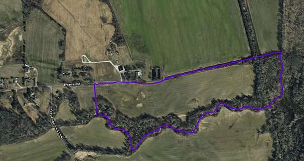
This property is 51 acres of farm land, currently being farmed for soybeans. You can access this land using Evans Lane. It is bordered on the south by Dry Branch Creek and to the east by the Middle Fork Forked Deer River.
Location
- Street address
- Evans Rd
- County
- Henderson County
Property details
- Acreage
- 51 acres
- Access
- Public road
- Showing
- Go on your own
- Posted
Legal description
Beginning at a point off the west margin of Independence Loop, along the original southern boundary of the Willodean Autry property described in Deed Book 173 at Page 16 in the Register's Office of Henderson County Tennessee, said beginning point also being the Northeast corner of the Tony Stegall 29.39 acre tract known as Map 55 Parcel 10.05, runs thence with the North boundary of the Stegall tract first in a southwesterly direction and then in a southerly direction a total of 315 feet more or less, thence runs continuing with that boundary in a more westerly direction 15 ft more or less to a point in the southeastern most corner of the Johnny Utley's tract totalling 45.5 acres more or less and known as Map 55 parcel 8, runs thence in a northwestly direction 600 feet more or less to an interior corner of Johnny Utley runs thence in a more northerlly direction bearing to the west to the south boundary of Independence Loop, runs thence with the south boundary of Independence Loop East to a point in the southwest intersection where Independence Loop intersects with Evans Road and then turns south, runs parallel with the western margin of Independence Loop.
Details and features
Lot
- View
- Farm
- Features
- Cleared, Level
Listing history
| Date | Event | Price | Change | Source |
|---|---|---|---|---|
| Oct 24, 2025 | New listing | $346,800 | — | Property seller |