Properties
Find agent
Post property
Log in
Sign up
Search here
List
Stockbridge, MA land for sale
Price
Size
Filters
Save search
76 properties
For you
For you
Newest
Price hi-lo
Price lo-hi
Size hi-lo
Size lo-hi
Updated
pending
Under contract
$550,000
19 acres
Berkshire County
Stockbridge, MA 01262
14 days
$749,900
11.6 acres
Columbia County
3 bd, 2 ba • 1,404 sq ft
Canaan, NY 12029
55 days ago
$695,000
11.7 acres
Berkshire County
8 ba • 18,157 sq ft
Great Barrington, MA 01230
$187k drop • Nov 5
$988,000
8.6 acres
Columbia County
4 bd, 4 ba • 2,245 sq ft
Canaan, NY 12029
$300k drop • Oct 2
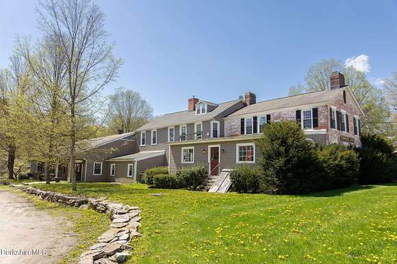
$1,975,000
15 acres
Berkshire County
5 bd, 5 ba • 6,000 sq ft
Alford, MA 01266
$100k drop • Oct 9
$1,700,000
20.3 acres
Columbia County
7 bd, 6 ba • 7,316 sq ft
Canaan, NY 12029
2 months ago
$3,750,000
11 acres
Berkshire County
4 bd, 5 ba • 5,300 sq ft
Great Barrington, MA 01230
2 months ago
$995,000
8 acres
Columbia County
3 bd, 3 ba • 3,204 sq ft
Canaan, NY 12060
2 months ago
$975,000
132 acres
Columbia County
3 bd, 2 ba • 1,795 sq ft
Austerlitz, NY 12060
2 months ago
$1,295,000
27.7 acres
Columbia County
3 bd, 3 ba • 2,194 sq ft
Hillsdale, NY 12529
18 days
$115,000
0.78 acres
Berkshire County
Lenox, MA 01240
54 days ago
$135,000
12.3 acres
Columbia County
Austerlitz, NY 12017
$30k drop • Nov 1
$569,000
3.8 acres
Berkshire County
2 bd, 2 ba • 1,100 sq ft
Egremont Town, MA 01230
$39k drop • Nov 1
$730,000
3.5 acres
Berkshire County
4 bd, 3 ba • 1,750 sq ft
Monterey, MA 01245
9 months ago
$1,595,000
101 acres
Columbia County
4 bd, 4 ba • 3,648 sq ft
New Lebanon, NY 12125
$40k drop • Nov 17
$719,000
3.3 acres
Berkshire County
3 bd, 3 ba • 2,117 sq ft
Monterey, MA 01230
3 months ago
$3,300/mo
3.53 acres
Columbia County
3 bd, 2 ba • 1,300 sq ft
Canaan, NY 12029
2 months ago
$2,250,000
200 acres
Berkshire County
3 bd, 2 ba • 2,990 sq ft
Great Barrington, MA 01230
$27k drop • Nov 26
$67,500
2.14 acres
Berkshire County
Richmond, MA 01254
7 months ago
$6,850,000
31 acres
Berkshire County
2 bd, 4 ba • 3,474 sq ft
Great Barrington, MA 01230
7 months ago
$3,700,000
228 acres
Columbia County
Austerlitz, NY 12017
$314k drop • Oct 10
$385,000
22 acres
Columbia County
2 bd, 1 ba • 1,525 sq ft
East Chatham, NY 12060
55 days ago
$525,000
7.5 acres
Berkshire County
3 bd, 1 ba • 1,698 sq ft
Great Barrington, MA 01230
$30k drop • Sept 24
$599,000
4.17 acres
Columbia County
4 bd, 3 ba • 2,569 sq ft
East Chatham, NY 12060
5 months ago
$1,880,000
367 acres
Columbia County
Canaan, NY 12037
7 months ago
$2,300,000
275 acres
Columbia County
Austerlitz, NY 12017
2 months ago
$115,500
11.4 acres
Columbia County
Canaan, NY 12029
8 months ago
$1,975,000
9.6 acres
Berkshire County
13 bd, 15 ba • 11,965 sq ft
Egremont Town, MA 01258
2 months ago
$841,000
4.74 acres
Berkshire County
3 bd, 2 ba • 1,826 sq ft
Lenox, MA 01240
2 months ago
$1,270,000
301 acres
Columbia County
4 bd, 2 ba • 1,344 sq ft
Hillsdale, NY 12529
7 months ago
$1,999,999
205 acres
Columbia County
Austerlitz, NY 12017
7 months ago
$895,000
150 acres
Columbia County
Hillsdale, NY 12529
7 months ago
$5,900,000
67 acres
Berkshire County
11 bd, 10 ba • 9,748 sq ft
Egremont Town, MA 01230
2 months ago
$69,000
5 acres
Columbia County
Canaan, NY 12029
7 months ago
$119,500
6 acres
Columbia County
Hillsdale, NY 12529
7 months ago
$1,250,000
2.2 acres
Berkshire County
4 bd, 11,991 sq ft
Egremont Town, MA 01258
3 months ago
$1,350,000
9.6 acres
Berkshire County
10 bd, 12 ba • 8,165 sq ft
Egremont Town, MA 01258
3 months ago
$219,000
3.62 acres
Berkshire County
West Stockbridge, MA 01266
5 months ago
$389,000
1.13 acres
Berkshire County
Egremont Town, MA 01258
2 years ago
$795,000
66 acres
Berkshire County
Great Barrington, MA 01230
11 months ago
$1,350,000
3 acres
Berkshire County
4 bd, 4 ba • 2,656 sq ft
Alford, MA 01230
$15k drop • Oct 23
$440,000
18 acres
Columbia County
3 bd, 3 ba • 2,784 sq ft
Canaan, NY 12029
$20k drop • Nov 20
$599,000
2 acres
Berkshire County
3 bd, 3 ba • 1,716 sq ft
Lee, MA 01238
7 months ago
$940,000
2.26 acres
Berkshire County
3 bd, 6,833 sq ft
Great Barrington, MA 01230
22 days
$3,630,000
242 acres
Columbia County
Austerlitz, NY 12017
$20k drop • Oct 19
$139,000
2.16 acres
Berkshire County
Great Barrington, MA 01230
$30k drop • Nov 30
$819,000
2 acres
Berkshire County
4 bd, 3 ba • 3,177 sq ft
Great Barrington, MA 01230
11 months ago
$3,900,000
225 acres
Berkshire County
2 bd, 2 ba • 12,207 sq ft
Great Barrington, MA 01230
8 months ago
$1,350,000
5 acres
Berkshire County
10 bd, 13 ba • 8,163 sq ft
Egremont Town, MA 01258
12 months ago
$999,999
7 acres
Berkshire County
6 bd, 9 ba • 4,695 sq ft
Lee, MA 01238
1
2
1-50 of 76 properties
View map