Commercial Land for Sale in Idaho Springs, Colorado
Lamartine Rd, Idaho Springs, CO 80452
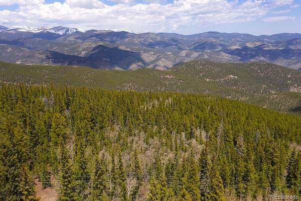
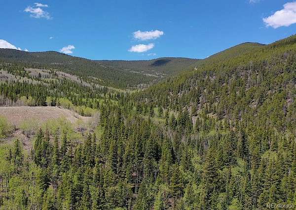
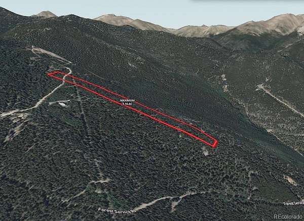
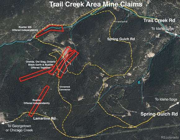
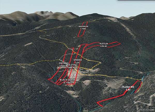
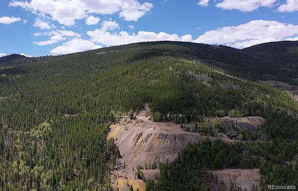
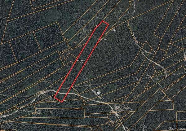
This 5.16 Acre parcel is a one of 7 Trail Creek Area Mining Claims offered just outside the Rocky Mountain Gateway town of Idaho Springs, Colorado. The larger collection of all 7 individual claims totals 32.042 acres with one additional 5 ac offering (MLS# 8233880) and the remaining 5 contiguous claims (MLS# 9105870) offered together at 21.882 acres. This 5.16 acre “Maximum” parcel lies off of Lamertine Rd approximately .94 mile from where it begins on Spring Gulch Rd. It is a narrow, densely forested property sloping towards the northeast with expansive viewsheds across the mountain ranges. Several properties along the access route have been developed with homes or cabins giving a window in to what could possibly be created. For 3 generations the ownership family has enjoyed these lands as a place to retreat, camp and recreate; from the lovely trickling stream of the Trail Creek upon the “Rustler MS” parcel to the expansive rocky mountain views offered from the middle clustered parcels and the high vantage point of the “Maximum” parcel. The Trail Creek Area Mining Claims just outside the Rocky Mountain Gateway town of Idaho Springs, Colorado are a collection of 7 individual claims totaling 32.042 acres. With the lower parcel located within 1/2 mile of the county maintained secondary roadway of Trail Creek Rd (road base), the parcels are then interconnected via a web of forest/county 4WD roads and tracks. A 4X4 enthusiasts dream; the network connects through to a myriad of rural mountain destinations including the old Lamartine townsite, Chicago, Ute & Cascade Creeks, Woodchuck Peak, Griffith Mountain, and the Saxon Mountain Road leading to Georgetown. For 3 generations the ownership family has enjoyed these lands as a place to retreat, camp and recreate; from the lovely trickling stream of Trail Creek upon the “Rustler MS” parcel to the expansive rocky mountain views offered from the middle clustered parcels and the high vantage point of the “Maximum” parcel.
- Listed by Bill Davis, (970) 390-8617, Keller Williams Foothills Realty
Location
- Street address
- Lamartine Rd
- County
- Clear Creek County
- Zip code
- 80452
- School district
- Clear Creek RE-1
- Elevation
- 10,307 feet
Directions
4X4 REQUIRED - The properties are best accessed from the Fall River Rd exit of I70. Take the exit to the south side frontage road Stanley Rd and turn left for 700' and take a hard right turn on to Trail Creek Rd (136) and travel 2.9 miles where it intersects with Spring Gulch Rd on the left. If only showing the upper "Maximum" parcel; it is easiest accessed by taking Spring Gulch Rd off of Trail Creek Rd for approximately 1.68 mi then take a hard right turn on to Lamartine Rd for .94 mile to the property. Most of parcel lies beneath the road. There is an unnamed much rougher Forest Rd about 2/3rds of the way along Lamartine which descends through to the other 5 parcels and ultimately back down to the Rustler MS parcel and Trail Creek Rd.
Property details
- Acreage
- 5.16 acres
- Zoning
- M-1
- MLS #
- REcolorado 6621345
- Posted
Property taxes
- 2024
- $1,030
Parcels
- 1961-062-00-639
Legal description
MINE: MAXIMUM - 2262A 5.16 ACRESTC 6-4-73 UND 2/3 INT
Details and features
Listing
- Type
- Land
- Subtype
- Unimproved Land
- Ownership
- Individual
- Terms
- Cash
- Exclusions
- N/A
- Possession
- Closing/DOD
Lot
- Vegetation
- Heavily Wooded, Mixed
- Road Frontage
- Public
- Road Surface
- Dirt
- View
- Mountain(s)
- Features
- Mountainous, Secluded, Sloped
Listing history
| Date | Event | Price | Change | Source |
|---|---|---|---|---|
| Apr 19, 2026 | New listing | $72,240 | — | REcolorado |
Payment calculator
Based on information submitted to the MLS GRID as of July 18, 2026 1:00 pm MT. All data is obtained from various sources and may not have been verified by broker or MLS GRID. Supplied Open House Information is subject to change without notice. All information should be independently reviewed and verified for accuracy. Properties may or may not be listed by the office/agent presenting the information. Some IDX listings have been excluded from this website. View more