Residential Land for Sale in Groom Creek, Arizona
Last Claim Ln, Groom Creek, AZ 86303
Spruce Mountain Property - Secluded 4 Acres in the Ponderosa Pines
Seclusion of this parcel lends itself to a private home location where one can preserve your viewshed, and natural surroundings since it is bordered on two sides by Prescott National Forest. This property is accessed by the year-round accessible Spruce Mountain maintained by the Spruce Mountain Road Maintenance Association (SMRMA) to which annual dues are paid.
The prime building area provides views to the northwest of the Prescott icons Thumb Butte and Granite Mountain. The bed of an ephemeral stream crosses low on the property. Vegetation includes ponderosa pine, white fir, alligator juniper and oaks. Some firewise clearing has been done, approximately 10 years ago. Electric power is located along the eastern border of the parcel. This parcel will require a well and onsite septic. Owner is able to meet interested parties and accompany to the subject parcel
Location
- Street address
- Last Claim Ln
- County
- Yavapai County
- Zip code
- 86303
- School district
- Prescott Unified SD #1
- Elevation
- 6,800 feet
Directions
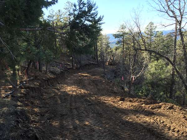
Directions and Access: Coming from Prescott, from the intersection of Gurley Street and Mt. Vernon Avenue drive south on Mt. Vernon/S. Senator Highway for approximately 4.75 miles to Spruce Mountain Road. Turn left onto Spruce Mountain Road and continue approximately 1.5 miles to Last Claim Lane. Turn right on Last Claim Lane and proceed approximately 0.4 mile to the crest of a hill where Last Claim Lane intersects a gravel/dirt driveway on your right to 4360 Last Claim Lane. Turn onto this driveway and proceed to park approximately 125 feet where a wire extends between two stone pillars. The right pillar resides at the southeast terminus of the legal easement to our parcel 104-14-046G. Posted to your right you can find a survey of Parcel 104-14-046G which also shows surrounding parcels 104-14-046E and 104-14-046H. After disconnecting the wire, please proceed on foot on the graveled drive to your right 125 feet and then left for 385 feet along a sloping, cleared and bulldozed easement to 104-14-046G. At the end of the easement you reach a bulldozed, leveled area at the southeast corner of Parcel 104-14-046G. Please observe private property by not trespassing on parcels -046E or -046H, and when you depart please reattach the wire between pillars.
Property details
- Acreage
- 4.01 acres
- Zoning
- R1L-175
- Access
- Private road
- Showing
- Contact for permission
- Posted
Property taxes
- 2026
- $1,194
Expenses
- Spruce Mountain Road Maintenance Association
- $200 annually
Parcels
- 104-14-046G
Legal description
Exhibit A
Parcel No. 1
All that portion of the PRINCE ALBERT Lode Claim located in the Hassayampa Mining District, Minerak Survey No. 3746, in Section 25, Township 13 North, Range 2 West, of the Gila and Salt River Base and Meridian, described as follows: BEGINNING at Corner No. 4 of said PRINCE ALBERT CLAIM, being the Southwesterly most claim corner, marked with a found 1/2 inch rebar tagged RLS 15331; THENCE North 04°26'15" West, measured (North 04°28" West, record) 1054.96 feet along the Westerly line of said claim to the TRUE POINT OF BEGINNING; THENCE North 04°26' 15" West 454.05 feet, measured (North 04°28" West, record) along said Westerly line to Corner No. 1 of the Prince Albert Lode Claim; THENCE North 85°23'38" East 214.17 feet to a point on the Northerly line of said PRINCE ALBERT Claim marked with a 1/2 inch rebar; THENCE South 04°28' 00" East 454.05 feet to a 1/2 inch rebar, THENCE South 85°23'38" West, 214.40 feet to the TRUE POINT OF BEGINNING
Parcel No. 2
Al that portion of the PRINCE ALBERT No. 6 Lode Claim located in the Hassayampa Mining (0) District, Mineral Survey No. 3746, in Section 25, Township 13 North, Range 2 West, of the Gila and Salt River Base and Meridian, described as follows:
BEGINNING at Corner No. 2 of said PRINCE ALBERT CLAIM, being the South easterly most corner; THENCE South 41°17' West 132.39 feet along the Southerly line of said claim to a 1/2 inch rebar; THENCE North 04°28' West 820.00 feet to a 1/2 inch rebar on the Northerly line of said claim;
THENCE North 41°17' East 132.39 feet to Corner No. 1 of said Prince Albert NO. 6 Lode Claim; THENCE South 04°28' East 820.00 feet to the POINT OF BEGINNING TOGETHER with those e a s e m e n t s for ingress, e g r e s s a n d utilities described in Deed recorded in Bool +205 of Official Records, page 464
Resources
Details and features
Lot
- View
- Mountain, Scenic, Woods
Property utilities
| Category | Type | Status | Description |
|---|---|---|---|
| Power | Grid | Available | Powerline exists along east boundary of parcel. |
Listing history
| Date | Event | Price | Change | Source |
|---|---|---|---|---|
| Sept 29, 2026 | New listing | $185,000 | — | Property seller |