Skip to main content
Skip to navigation
Properties
Find agent
Post property
Log in
•
Sign up
Search here
List
Oatman, AZ land for sale
Price
Size
Tags
Save
34 properties
For you
Newest
Price: high to low
Price: low to high
Size: large to small
Size: small to large
Updated
Featured
11 months ago
$13,000
2.35 acres
Mohave County
Golden Valley, AZ 86413
Featured
10 months ago
$11,000
2.35 acres
Mohave County
Golden Valley, AZ 86413
Featured
2 months ago
$1,700,000
172 acres
Mohave County
Fort Mohave, AZ 86426
29 days
$12,000
2.35 acres
Mohave County
Golden Valley, AZ 86413
20 days
$89,000
2.2 acres
Mohave County
Golden Valley, AZ 86413
33 days ago
$19,000
2.35 acres
Mohave County
Golden Valley, AZ 86413
20 days
$89,500
2.2 acres
Mohave County
Golden Valley, AZ 86413
$100k drop • Mar 26
$990,000
644 acres
Mohave County
Golden Valley, AZ 86413
5 months ago
$11,500
2.35 acres
Mohave County
Golden Valley, AZ 86413
$70k drop • Mar 26
$540,000
407 acres
Mohave County
Golden Valley, AZ 86413
50 days ago
$11,000
2.35 acres
Mohave County
Golden Valley, AZ 86401
56 days ago
$24,900
5 acres
Mohave County
Golden Valley, AZ 86413
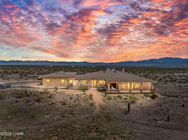
5 months ago
$949,000
61.2 acres
Mohave County
3 bd, 2.5 ba
•
3,600 sq ft
Oatman, AZ 86433
$2.5k drop • Mar 12
$35,000
2.35 acres
Mohave County
Golden Valley, AZ 86413
2 months ago
$9,500
2.35 acres
Mohave County
Golden Valley, AZ 86413
$74.9k drop • Jan 15
$425,000
10.2 acres
Mohave County
3 bd, 3 ba
•
1,768 sq ft
Oatman, AZ 86433
4 months ago
$9,000
2.35 acres
Mohave County
Golden Valley, AZ 86413
28 days
$9,000
2.35 acres
Mohave County
Golden Valley, AZ 86413
3 months ago
$39,900
9.12 acres
Mohave County
Golden Valley, AZ 86413
2 years ago
$10,900
1.18 acres
Mohave County
Golden Valley, AZ 86413
$1.09k drop • Feb 1
$5,900
2.35 acres
Mohave County
Golden Valley, AZ 86413
45 days ago
$19,350
7.53 acres
Mohave County
Golden Valley, AZ 86413
11 months ago
$57,770
38.2 acres
Mohave County
Golden Valley, AZ 86413
3 months ago
$8,000
2.2 acres
Mohave County
Golden Valley, AZ 86413
18 months ago
$98,500
12.4 acres
Mohave County
Oatman, AZ 86433
20 months ago
$20,000
5 acres
Mohave County
Golden Valley, AZ 86413
13 months ago
$99,000
41.7 acres
Mohave County
Mohave Valley, AZ 86440
Pending
Under contract
$799,900
40 acres
Mohave County
4 bd, 2 ba
•
3,796 sq ft
Golden Valley, AZ 86413
32 days ago
$100,000
46 acres
Mohave County
Oatman, AZ 86433
33 days ago
$7,500
2.35 acres
Mohave County
Golden Valley, AZ 86413
4 months ago
$250,000
120 acres
Mohave County
Oatman, AZ 86436
$1k drop • Feb 18
$7,000
2.2 acres
Mohave County
Golden Valley, AZ 86413
$4.9k drop • Feb 18
$15,000
7 acres
Mohave County
Golden Valley, AZ 86413
Pending
Under contract
$15,750
5.2 acres
Mohave County
Golden Valley, AZ 86413
Map