Land for Sale in Webbers Falls, Oklahoma
Muskogee County, Webbers Falls, OK 74470
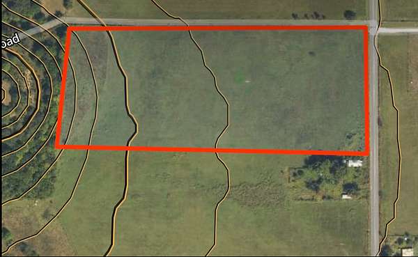
This clear, mostly level 15-acre parcel offers a prime opportunity for a homesite, small livestock operation, or rural getaway. Featuring generous dual road frontage along a paved county road, access is straightforward and versatile. The land consists predominantly of wide-open, gently sloping pasture with minimal tree cover, making site preparation straightforward for building, grazing, or farming.
Key Features & Highlights
- Acreage & Topography: ~15 acres of open, gently rolling grass pasture with minimal timber along the western fringe, providing clear build sites and wide-open views.
- Road Frontage & Access: Direct frontage along S 155th St E and E 228th St S (N County Rd 4440 area), offering convenient corner access and layout options for drives, barns, or cross-fencing.
- Utilities: Electric, Fiber Optic Internet, and Water available at the road
- Land Use Potential: Ideal for horses, cattle, agricultural projects, or a custom rural home with ample space for shop buildings, outbuildings, and garden setups.
- Location: Enjoy quiet country living with scenic distant ridge views, while retaining easy county road connection to nearby towns.
Location
- County
- Muskogee County
- Zip code
- 74470
- School district
- Webbers Falls
Property details
- Acreage
- 15 acres
- Showing
- Contact for permission
- Posted
Legal description
A 15.00 acre tract of land located in the North Half of the Northeast Quarter of the Southeast Quarter (N/2-NE/4-SE/4) of Section 18, Township 11 North, Range 21 East of the Indian Meridian, Muskogee County, State of Oklahoma more particularly described as follows: BEGINNING at an existing Mag Nail marking the NE/c of the N/2-NE/4-SE/4 of said Section 18; Thence S02°08′24″E along the East Line of the N/2-NE/4-SE/4, 496.11 feet to a set Mag Nail w/LS2001 Washer, Thence S87°44′38″W, 1317.04 feet to a set ⅝" Iron Rod w/LS2001 Cap on the West Line of the N/2-NE/4-SE/4; Thence N02°04′22″W along the West Line of the N/2-NE/4-SE/4, 496.11 feet to an existing 1" Iron Pipe marking the NW/c of the N/2-NE/4-SE/4; Thence N87°44′38″E along the North Line of the N/2-NE/4-SE/4, 1316.45 feet to the Point of Beginning, containing 15.00 acres more or less.
Details and features
Lot
- Features
- Cleared
Listing history
| Date | Event | Price | Change | Source |
|---|---|---|---|---|
| Sept 22, 2026 | Price increase | $150,000 | $10,000 7.1% | Property seller |
| Sept 21, 2026 | New listing | $140,000 | — | Property seller |