Land for Sale in Bentonville, Arkansas
Brush Arbor Bentonville, AR 72712
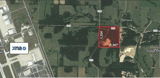
Image
Map
$1,600,000
39.78 acres
Active sale agoEst $12,327/mo
Red dirt opportunity! Approx. 29.35 acres of red dirt. Remaining 10.43 acres low land. Across from the Northwest Arkansas National Airport. 25 minutes from Downtown Bentonville
Directions
From Hwy 102, south on SW I St. Continue south then west onto Healing Springs Rd that turns into Hwy 264. North onto Hwy 279 or Brush Arbor Rd. Property is to the east of Brush Arbor Rd & Waddell Rd.
Location
- Street Address
- Brush Arbor
- County
- Benton County
- School District
- Bentonville
- Elevation
- 1,220 feet
Property details
- MLS Number
- ARMLS 1214289
- Date Posted
Parcels
- 18-09295-000
Legal description
SE NE BEG NW/C SE NE S88*E1312.95' S1*W1319.57' N88*W1316.52' N1*E1316.52' POB
Listing history
| Date | Event | Price | Change | Source |
|---|---|---|---|---|
| Apr 1, 2024 | Relisted | $1,600,000 | — | ARMLS |
| Mar 31, 2024 | Listing removed | $1,600,000 | — | — |
| Apr 4, 2022 | New listing | $1,600,000 | — | ARMLS |
Payment calculator
Contact listing agent
By submitting, you agree to the terms of use, privacy policy, and to receive communications.