Agricultural Land for Sale in Cut Bank, Montana
Radar Base Rd Cut Bank, MT 59427
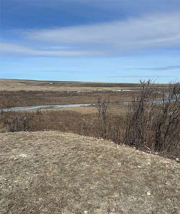
This mix of pasture and agricultural property is located along the beautiful Milk River, just about 5 miles South of the Del Bonita Border Crossing. Contact Nick Crawford at 406-845-8486, or your real estate professional. This property is currently under trust management but we will be accepting back-up offers contingent on the Blackfeet Tribes release of the property.
Directions
From Cut Bank Mt., drive North on Hwy 213 for 45 miles until you reach Radar Base Road, which will be located on the left side of the road (West). Turn onto and drive West down Radar Base Road approximately 4 miles until you reach a large circular irrigation pivot, which will be located on your left as you drive West. The parcels are located within the fenced/gated area.
Location
- Street Address
- Radar Base Rd
- County
- Glacier County
- Elevation
- 4,203 feet
Property details
- MLS Number
- MWMTAR 30022124
- Date Posted
Parcels
- 38484401102010000
Legal description
Sec 1, T36N, R10W, LOT 02=NW NE, NW SE, N SE NW, SW NE, LOT 03=NE NW, S SE, N S SE, NW. Sec 6, T36N, R9W, SE SW, LOT 07=SW SW. Sec 33 T35N, R7W, NW NE.
Detailed attributes
Listing
- Type
- Land
- Subtype
- Unimproved Land
- Franchise
- Keller Williams Realty
Lot
- Views
- Mountain
- Features
- River Access, Waterfront
Exterior
- Features
- Level
Listing history
| Date | Event | Price | Change | Source |
|---|---|---|---|---|
| Mar 29, 2024 | New listing | $825,000 | — | MWMTAR |