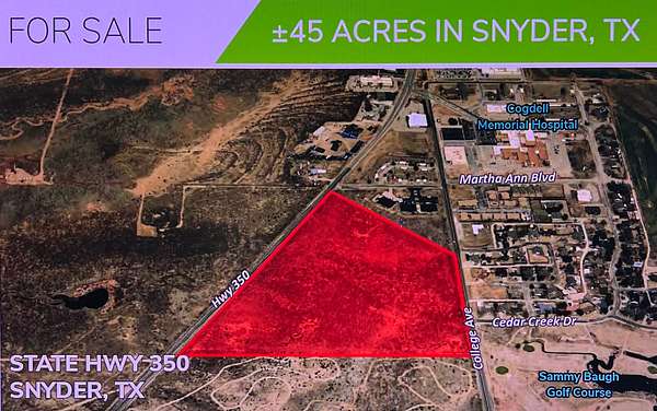
Commercial Land for Sale in Snyder, Texas
State Highway 350, Snyder, TX 79549
45+ acres of land on the east side of State Highway 350 and College Avenue directly across from the Sammy Baugh Golf Course, Western College and Cogdell Memorial Hospital.
Located on the southside of Snyder TX, which is 80 miles from Abilene and 39 miles from Sweetwater.
Property is located near the Deep Creek Edge, Royal Cedar and Cedar Creek Lynwood Subdivisions.
Location
- Street address
- State Highway 350
- County
- Scurry County
- Zip code
- 79549
- School district
- Snyder ISD
Property details
- Acreage
- 45 acres
- Zoning
- Snyder ETJ
- Access
- Public road
- Showing
- Go on your own
- Posted
Parcels
- 154569
Legal description
BEGINNING at a 1/2” Iron Rod/cap marked “STEWART SURVEYING” set for the northeast corner of this tract at the intersection point of the south line of Martha Ann Boulevard and the west line of College Avenue from which point a 1/2”Iron Rod in concrete found for the northeast corner of said Section 183 bears S 89°54’ 16”E a distance of 45.00 feet and NORTH a distance of 1366.48 feet;
THENCE SOUTH along the east line of this tract and the west line of College Avenue for a distance of 1704.04 feet to a 1/2”Iron Rod/cap marked “STEWART SURVEYING” set for the southeast corner of this tract from which point a 1/2”Iron Rod/cap marked “STEWART SURVEYING” found for the northeast corner of a 40.000 acre tract of land conveyed to Western Texas College by deed recorded in Volume 684, Page 253, Official Public Records of Scurry County, Texas bears SOUTH a distance of 869.42 feet;
THENCE N 89°54’16” W along the south line of this tract for a distance of 1836.06 feet to a 1/2”Iron Rod/cap marked “STEWART SURVEYING” set in the east right-of-way line of State Highway No. 350 for the southwest corner of this tract;
THENCE N 33°15’37” E along the west line of this tract and the east line of said State Highway No. 350 for a distance of569.74 feet to a concrete Right-of-way Marker found for a corner of this tract; THENCE N 33°14’00” E along the west line of this tract and the east line of said State Highway No. 350 for a distance of 1465.44 feet to a 1/2”IronRod/cap marked “STEWART SURVEYING” found for the northwest corner of this tract at the intersection of the east line of State Highway No. 350 and the south line of said Martha Ann Boulevard from which point a 3/4” Iron Rod found bears N 33°14’00” E a distance of 107.49 feet;
THENCE S 89°54’16” E along the north line of this tract and the south line of Martha Ann Boulevard for a distance of720.45 feet to the place of beginning.
SAVE AND EXCEPT a 5.000 acre tract described in Warranty Deed dated September 22, 2016 from Scurry County Hospital District to Sterling Management Company of New Mexico, LLC, recorded in Volume 890, Page 176, Official Public Records, Scurry County, Texas; as corrected in Volume 1008, Page 25, Official Public Records, Scurry County, Texas.
SAVE AND EXCEPT all of the oil, gas and other minerals in, on and under and that may be produced and saved from the above-described property; same having been previously reserved.
SUBJECT TO any and all valid and subsisting covenants, restrictions, reservations, easements and rights of-way properly found of record.
Resources
Listing history
| Date | Event | Price | Change | Source |
|---|---|---|---|---|
| May 26, 2026 | Price drop | $750,000 | $250,000 -25% | Listing agent |
| May 15, 2025 | New listing | $1,000,000 | — | Listing agent |