Skip to main content
Skip to navigation
Properties
Find agent
Post property
Log in
•
Sign up
Search here
List
Sparta, TN land for sale
Price
Size
Tags
Save
272 properties
For you
Newest
Price: high to low
Price: low to high
Size: large to small
Size: small to large
Updated
11 days
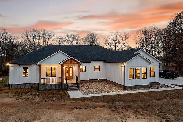
$2,375,000
6.77 acres
DeKalb County
3 bd, 5 ba
•
7,188 sq ft
Sparta, TN 38583
20 days
$80,000
1.68 acres
DeKalb County
Sparta, TN 38583
20 days
$80,000
1.68 acres
DeKalb County
Sparta, TN 38583
29 days
Auction
$— min
190 acres
White County
Quebeck, TN 38579
29 days
$312,000
6.44 acres
White County
3 bd, 2 ba
•
1,512 sq ft
Sparta, TN 38583
13 days
$1,100,000
126 acres
DeKalb County
Sparta, TN 38583
42 days ago
$600,000
26.9 acres
DeKalb County
1 bd, 1 ba
•
1,100 sq ft
Sparta, TN 38587
$16k drop • Mar 5
$176,000
32 acres
White County
Sparta, TN 38583
5 days
$1,599,900
10.8 acres
Putnam County
4 bd, 4.5 ba
•
4,900 sq ft
Sparta, TN 38583
20 days
$80,000
1.5 acres
DeKalb County
Sparta, TN 38583
2 months ago
$1,600,000
66 acres
White County
2 bd, 2 ba
•
1,289 sq ft
Sparta, TN 38583
$50k drop • Mar 31
$949,000
29.3 acres
Putnam County
Baxter, TN 38544
2 months ago
$549,900
22 acres
Van Buren County
Doyle, TN 38559
3 months ago
$350,000
2 acres
DeKalb County
Sparta, TN 38583
8 days
$649,900
6 acres
White County
3 bd, 2 ba
•
2,880 sq ft
Sparta, TN 38583
14 days
$429,900
11.7 acres
White County
3 bd, 2 ba
•
1,756 sq ft
Sparta, TN 38583
48 days ago
$548,900
4.5 acres
White County
4 bd, 4 ba
•
3,266 sq ft
Sparta, TN 38583
54 days ago
$445,000
5.46 acres
White County
3 bd, 3 ba
•
2,068 sq ft
Sparta, TN 38583
3 months ago
$525,000
32.2 acres
White County
Walling, TN 38587
5 months ago
$3,630,500
170 acres
White County
Sparta, TN 38583
4 days
$269,000
3.5 acres
White County
4 bd, 2 ba
•
1,836 sq ft
Walling, TN 38587
14 days
$219,000
6.69 acres
White County
Sparta, TN 38583
15 days
$429,900
11.7 acres
White County
3 bd, 2 ba
•
1,756 sq ft
Sparta, TN 38583
36 days ago
$299,900
5 acres
White County
1 bd, 1 ba
•
600 sq ft
Sparta, TN 38583
12 days
$2,599,000
3.6 acres
DeKalb County
3 bd, 4.5 ba
•
3,251 sq ft
Sparta, TN 38582
29 days
$950,000
109 acres
White County
Sparta, TN 38583
2 months ago
$35,900
1.17 acres
DeKalb County
Sparta, TN 38583
3 months ago
$1,790,000
30 acres
White County
8 bd, 6.5 ba
•
4,100 sq ft
Sparta, TN 38583
5 months ago
$1,419,000
64.5 acres
White County
Sparta, TN 38583
53 days ago
$330,000
27.5 acres
White County
Quebeck, TN 38579
53 days ago
$119,000
5 acres
White County
Quebeck, TN 38579
5 months ago
$1,437,500
62.5 acres
White County
Sparta, TN 38583
5 months ago
$774,000
43 acres
White County
Sparta, TN 38583
5 months ago
$659,900
5 acres
White County
3 bd, 2 ba
•
1,921 sq ft
Sparta, TN 38583
13 days
$219,000
6.69 acres
White County
Sparta, TN 38583
14 days
$219,000
7.25 acres
White County
Sparta, TN 38583
2 months ago
$135,000
2.74 acres
DeKalb County
Sparta, TN 38583
2 months ago
$1,199,000
15 acres
White County
3 bd, 3 ba
•
3,860 sq ft
Sparta, TN 38583
$150k drop • Jan 5
$1,500,000
84.7 acres
DeKalb County
Sparta, TN 38583
4 days
Auction
$— min
130 acres
White County
Sparta, TN 38583
53 days ago
$119,000
5 acres
White County
Quebeck, TN 38579
$14k drop • Mar 10
$615,000
3.35 acres
DeKalb County
3 bd, 3 ba
•
3,500 sq ft
Sparta, TN 38583
4 months ago
$749,900
4.1 acres
White County
5 bd, 2.5 ba
•
4,076 sq ft
Sparta, TN 38583
3 days
$529,900
2.19 acres
White County
4 bd, 3.5 ba
•
3,759 sq ft
Sparta, TN 38583
18 days
$40k drop • Mar 27
$549,929
5 acres
White County
3 bd, 2 ba
•
1,776 sq ft
Sparta, TN 38583
25 days
$20k drop • Mar 30
$429,990
5.69 acres
White County
4 bd, 3 ba
•
1,740 sq ft
Walling, TN 38587
4 months ago
$99,900
3.15 acres
White County
Sparta, TN 38583
$298k drop • Feb 19
$1,552,500
135 acres
White County
Walling, TN 38587
1 day
$129,000
5 acres
DeKalb County
Sparta, TN 38583
29 days
$195,000
10.1 acres
DeKalb County
Sparta, TN 38583
1
2
3
4
…
6
1-50 of 272 properties
Map